

Central North Carolina is experiencing a severe, long-term drought that began in August 2025 for many areas, the National Weather Service reported today.
The severity varies by region
Exceptional Drought (D4): Developed/re-emerged across parts of the northern Piedmont and Triangle areas, accounting for roughly 3.01 percent of statewide coverage.
Extreme Drought (D3): Covers 33.81 percent of the area, stretching across the Northern Piedmont and Northern Coastal Plain.
Severe Drought (D2): Encompasses 52.98 percent of the region, specifically impacting the Southern Piedmont and Southern Coastal Plain.
Precipitation deficits & historical context
Raleigh: Experienced its driest spring on record through May 31 and currently has a precipitation deficit near 20 inches since August 2025. Over the past 90 days, the area received just 37 percent of its normal rainfall.
Greensboro: Logged its third-driest spring on record, receiving only 47 percent of its normal 90-day rainfall.
Chapel Hill: Recording its driest start to any year since 1893, the area has seen only 10.10 inches of precipitation since January 1 —more than 10 inches below normal 50 percent of the normal precipitation.
Observed impacts
Water Supplies: Numerous municipalities have enacted voluntary or mandatory water conservation measures. Rocky Mount has requested Stage II conservation as the Tar River Reservoir is down to 84 percent capacity, while the Falls Lake water supply has dropped to 69 percent..
Streamflow & groundwater: Groundwater levels in the Piedmont are near record lows, and multiple streams and rivers across central North Carolina have hit all-time record lows, with some stopping flow entirely.
Agriculture: The USDA/NASS reports that 57 percent of hay is in poor or very poor condition. There is severe stress on vital crops like corn and soybeans, leading to widespread concerns over impending shortages.
Wildfires: The Rose Bay Canal fire has burned 455 acres across dry vegetation and deep organic soils, and was only 20 percent contained at the time of the report.
Weather outlooks and temperature anomalies
Recent temperatures: The past 30 days have trended near to above normal, culminating in intense heat during the first week of June.
Short-term forecast for the next 7 to 10 days: A hot, humid summer pattern will drive temperatures into the upper 90s, likely hitting 100. While scattered daily afternoon thunderstorms are possible, rainfall is projected to be near-normal at best.
Extended outlooks: Both the 8–14 day and Weeks 3–4 outlooks favor above-normal temperatures — 40–50 percent chance. Although there is a slight 30–40 percent lean toward above-normal precipitation by late June, there remains a 60–70 percent chance that rainfall stays near or below normal.
Seasonal outlook: Above-normal temperatures are favored 40–50 percent chance for June–August, with equal chances for above or below-normal rainfall.
Main impact: There is no clear signal for significant drought improvement through the summer.
Long-term climate drivers
The Climate Prediction Center has issued an El Niño Watch. Models indicate a high probability that an El Niño — potentially a very strong one — will develop soon and persist into the upcoming winter. While it offers no immediate relief to the summer drought, El Niño winters historically favor wetter-than-normal conditions across the southern United States.


Virginia
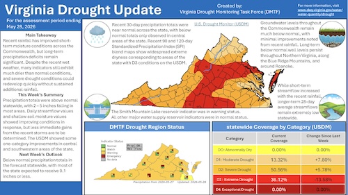
Due to lack of more frequent and prolonged precipitation across most of the Commonwealth over the past two weeks, the Virginia Department of Environmental Quality in coordination with the Drought Monitoring Task Force continued the existing drought advisory statuses for Virginia.
All of Virginia is in a drought warning, with the exception of Isle of Wight County, and the cities of Chesapeake, Norfolk, Portsmouth, Suffolk, and Virginia Beach in southeast Virginia, which remain in a drought watch.
A drought warning advisory is intended to increase awareness that the onset of a significant drought event is imminent. A drought watch advisory is intended to help Virginians prepare for a potential drought.
The DMTF primarily considers four drought indicators in establishing drought advisories: precipitation, groundwater levels, streamflow, and reservoir levels. Streamflows and soil moisture have continued to decline, with deeper soil moisture and groundwater also remaining much below normal. Groundwater levels in 13 of the state’s 24 monitoring wells remain below the 10th percentile for this time of the year.
Long-term outlooks for groundwater levels remain a concern and will take a prolonged period of rainfall to recover.
Average statewide precipitation is approximately 7.5 inches below normal
for the water year, which began on Oct. 1, 2025. Without prolonged periods of rainfall, the drought will worsen as temperatures rise and rates of evapotranspiration increase. Worsening conditions could cause the drought advisory to be upgraded from warning to emergency status in certain localities—thereby triggering potential water restrictions.
DEQ and the DMTF are assessing the situation and will continue to provide updates every two weeks for the duration of the drought.
Additional information on the current drought status is available on the DEQ Drought webpage and Drought Dashboard, which includes interactive data on stream gages, groundwater wells, soil moisture, and precipitation.


