

The National Weather Service reported the following today:
Frost advisory
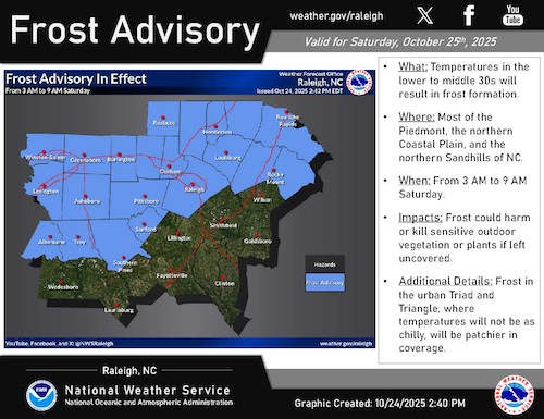
A frost advisory has been issued and is in effect from 3 a.m. to 9 a.m. Saturday for most of the Piedmont, the northern Coastal Plain, and the northern Sandhills of North Carolina, where temperatures in the lower to middle 30s are expected.
Drought Monitor
The U.S. Drought Monitor released Thursday and valid as of Tuesday shows an expansion of severe drought in the Coastal Plain and eastern Piedmont.
Aside from one coastal low on October 11-12, rainfall deficits continue to grow since early August.
Severe drought has expanded in the north central Coastal Plain, eastern Piedmont, and has also developed into the southern Piedmont. Moderate drought has expanded across nearly all of the Piedmont. Conditions continue to degrade statewide, the North Carolina State Climate Office said. “Moisture from our mid-month nor’easter soaked in quickly with little replenishment last week, as saw less than half an inch of rain during Sunday’s cold frontal passage,” the report says. “These fronts can also bring gusty winds and low-humidity air, which ramps up fire danger as we already saw this Wednesday and Thursday. Expect the fire season to ramp up as leaf fall continues.”


Temperatures this weekend are expected to tumble with patchy frost possible on Saturday morning. By early next week moisture may return with light rain across the state. Rainfall deficits continue to grow across the Coastal Plain.
Rainfall in the last 30 days has been 25 to 30 percent of normal and an observer in Rocky Mount has reported only 1.06 inches of rain since the beginning of September.
The report notes that soil moisture across much of the Coastal Plain is in the lowest 5 to 10th percentiles for this time of year and the short-term crop moisture index is between -1 and -3.
There have been some reported agricultural impacts, including lower soybean production and cool-season forage crop issues.
Over the next week a coastal low will track along the coast and bring the chance of a couple of rounds of rainfall to central North Carolina.
As much as 1 to 2 inches of rain is possible although there is still some uncertainty in the amounts. Current forecasts do imply near to above normal rainfall through late next week.


