


The National Weather Service in Raleigh has issued a critical weather briefing as a powerful storm system prepares to sweep across central North Carolina today.
Residents are urged to remain weather-aware as the region faces a moderate risk —level 4 of 5 — for severe thunderstorms.
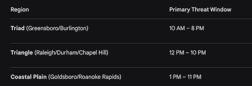
Forecasters have high confidence that a broken line of storms will bring a variety of dangerous conditions to the area this afternoon and evening.
Destructive Winds: This is the primary concern today, with a 45% to 60% probability of widespread damaging wind gusts. Some significant gusts could exceed 74-75 mph.
Tornado Threat: There is a 10% to 15% probability of tornadoes. While many may be brief, some could be significant, reaching EF-2 intensity or stronger.
Large Hail: The probability of damaging hail has been lowered to roughly 5%, though isolated instances of 2-inch hail remain possible.
Rapid Storm Movement: These storms will be moving extremely fast—potentially toward the northeast at 60 mph or faster.
Because of the high forward speed of these storms, you will have very little time to react. If a warning is issued for your area, move to shelter immediately.
The National Weather Service emphasizes the importance of having multiple ways to receive watches and warnings today. Frequent cloud-to-ground lightning and heavy downpours are also expected, particularly across the Coastal Plain.


