

Forecasters at NOAA’s Climate Prediction Center, a division of the National Weather Service, are predicting above-average hurricane activity this year — which would make it the seventh consecutive above-average hurricane season.
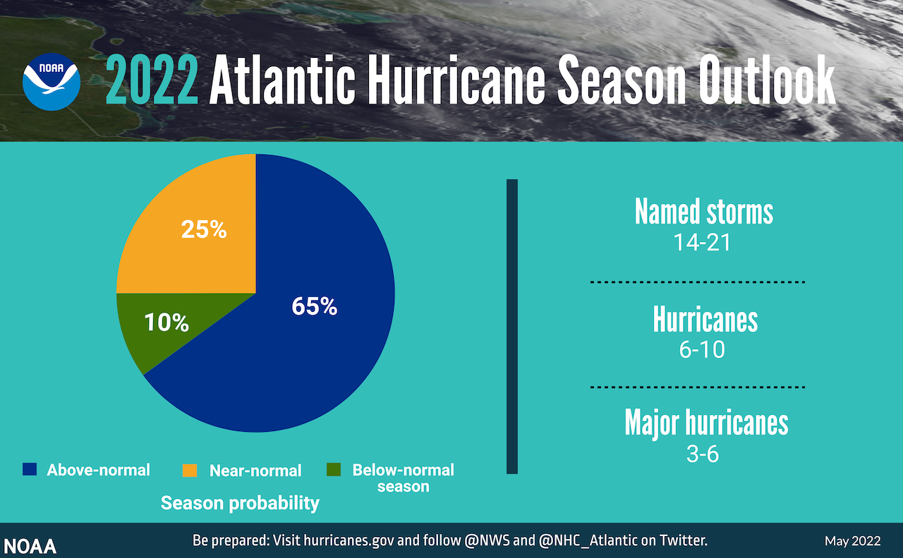
NOAA’s outlook for the 2022 Atlantic hurricane season, which extends from June 1 to November 30, predicts a 65 percent chance of an above-normal season, a 25 percent chance of a near-normal season and a 10 percent chance of a below-normal season.
For the 2022 hurricane season, NOAA is forecasting a likely range of 14 to 21 named storms — winds of 39 mph or higher — of which six to 10 could become hurricanes — winds of 74 mph or higher — including three to six major hurricanes — category 3, 4 or 5 with winds of 111 mph or higher.
NOAA provides these ranges with a 70 percent confidence.


“Early preparation and understanding your risk is key to being hurricane resilient and climate-ready,” said Secretary of Commerce Gina M. Raimondo. “Throughout the hurricane season, NOAA experts will work around-the-clock to provide early and accurate forecasts and warnings that communities in the path of storms can depend on to stay informed.”
The increased activity anticipated this hurricane season is attributed to several climate factors, including the ongoing La Niña that is likely to persist throughout the hurricane season, warmer-than-average sea surface temperatures in the Atlantic Ocean and Caribbean Sea, weaker tropical Atlantic trade winds and an enhanced west African monsoon.
An enhanced west African monsoon supports stronger African Easterly Waves, which seed many of the strongest and longest lived hurricanes during most seasons. The way in which climate change impacts the strength and frequency of tropical cyclones is a continuous area of study for NOAA scientists.
“As we reflect on another potentially busy hurricane season, past storms — such as Superstorm Sandy, which devastated the New York metro area ten years ago — remind us that the impact of one storm can be felt for years,” said NOAA Administrator Rick Spinrad. “Since Sandy, NOAA’s forecasting accuracy has continued to improve, allowing us to better predict the impacts of major hurricanes to lives and livelihoods.”
Deanne Criswell, FEMA administrator, said, “Hurricane Ida spanned nine states, demonstrating that anyone can be in the direct path of a hurricane and in danger from the remnants of a storm system. It’s important for everyone to understand their risk and take proactive steps to get ready now by visiting Ready.gov and Listo.gov for preparedness tips, and by downloading the FEMA App to make sure you are receiving emergency alerts in real-time.”
NOAA’s outlook is for overall seasonal activity and is not a landfall forecast.
North Carolina Department of Transportation
Meanwhile the North Carolina Department of Transportation announced Monday that when the next hurricane strikes, it will be armed with an advanced flood-warning system that relies on a network of 400 river and stream gauges.
The new system will allow the NCDOT for the first time to analyze, map and communicate in real-time any flood risks to roads, bridges and culverts.
This critical information will go to NCDOT maintenance staff responding to flooded roads and washed-out culverts; and it will benefit local emergency management officials and the public accessing the department's DriveNC.gov website for timely weather-related closures.
“This state-of-the-art warning system our department has created will help us be better prepared for the next major storm," Transportation Secretary Eric Boyette said. “Even though we've had some quiet hurricane seasons recently, we cannot let our guard down."
The last major storm to impact the state's road network was Hurricane Florence in 2018. Researchers at North Carolina State University and the National Hurricane Center are predicting an above-average hurricane season, which officially starts June 1.
After Florence, the state Legislature gave the NCDOT a $2 million grant to develop sophisticated software and install more flood gauges. The system, however, mostly taps into existing gauges operated by other agencies, such as North Carolina Emergency Management and the U.S. Geological Survey. The system includes an interactive online dashboard and flood mapping based on three-dimensional ground surveys.
One part of the new early flood-warning system covers almost 3,000 miles of state-maintained roads, mostly east of Interstate 95.
The system also will allow NCDOT to monitor flood conditions for some 15,000 bridges and culverts statewide. The agency's Hydraulics Unit has been fine-tuning the system and training staff on it with smaller storms over the past year.
In addition, the NCDOT has formed a recent partnership with the University of North Carolina at Chapel Hill's Renaissance Computing Institute and the U.S. Department of Homeland Security's Coastal Resilience Center of Excellence to receive forecast modeling data on how storm surge may affect the state's road network in coastal areas.


